Bihar Spared as Cyclonic Storm ‘Hamoon’ Veers Away, Intensifies Towards Bangladesh Coast: IMD
Patna – The Severe Cyclonic Storm “Hamoon” is expected to spare Bihar from any significant weather disruptions, according to the latest bulletin by the India Meteorological Department (IMD). While some parts of the southern region may experience partly cloudy skies, overall weather conditions in the state are anticipated to remain relatively stable over the next 24 hours.
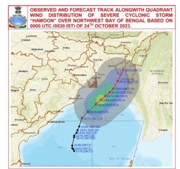
As of Tuesday morning, the IMD reported that Cyclone Hamoon, situated over the northwest Bay of Bengal, had shifted northeastwards over the past six hours. Its current position is approximately 230 kilometers east-southeast of Paradip in Odisha, 240 kilometers south-southeast of Digha in West Bengal, 280 kilometers south-southwest of Khepupara in Bangladesh, and 410 kilometers southwest of Chittagong, also in Bangladesh.
The IMD’s special bulletin indicated that Cyclone Hamoon is highly likely to intensify further, developing into a very severe cyclonic storm within the next six hours. Subsequently, it is expected to gradually weaken as it continues its northeastward trajectory. The cyclone is projected to make landfall on the Bangladesh coast between Khepupara and Chittagong on the evening of October 25, with wind speeds ranging from 65 to 75 kilometers per hour, gusting to 85 kilometers per hour.
In its regional forecast, the national weather forecasting agency has predicted light to moderate rainfall in Manipur, Mizoram, Tripura, south Assam, and Meghalaya in the northeastern part of India on both October 24 and October 25. Additionally, coastal districts in Odisha and West Bengal are likely to experience light to moderate rainfall over the next 24 hours.
For neighboring Jharkhand, isolated areas may witness rainfall today and tomorrow, while dry weather conditions have been forecasted for Bihar.