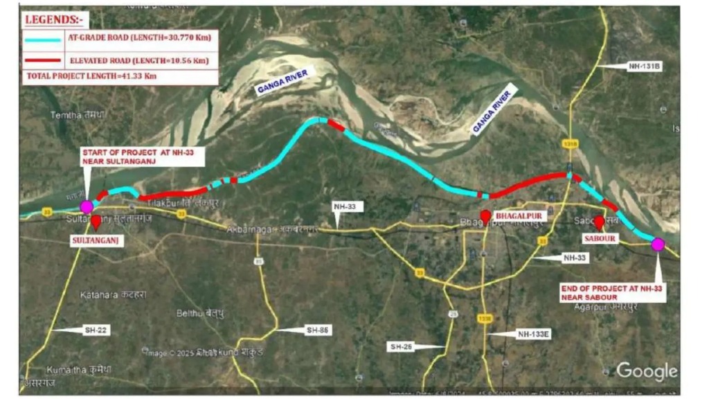
Bhagalpur/Patna: The proposed Marine Drive connecting Sultanganj, Bhagalpur and Sabour has moved beyond the conceptual stage, with the Bihar State Road Development Corporation Limited (BSRDCL) preparing a pre-feasibility report for the 41.33-km four-lane greenfield corridor.

The project will require approximately 668.824 acres of land across five administrative blocks and is proposed to be constructed by the Adani Group, with BSRDCL responsible for its implementation.
The proposed road is designed to improve connectivity along the Sultanganj-Bhagalpur-Sabour stretch, where increasing traffic, dense settlements and narrow existing roads have slowed movement and raised transport costs.

30.77 Km At Ground Level, 10.56 Km Elevated
The proposed corridor will have a total length of 41.33 km within Bhagalpur district, comprising 30.77 km of at-grade road and 10.56 km of elevated sections.
The road will have a proposed design speed of 100 km/h, potentially reducing travel times between the three major locations.
Two major elevated sections measuring 1,570 metres and 8,990 metres are planned as part of the project.
The infrastructure package also proposes:
- Four major bridges
- Two minor bridges
- Nine vehicular underpasses
- Nine light-vehicle underpasses
- 18 small vehicular underpasses
- 67 culverts
- Plantation along both sides of the corridor
A T-junction is proposed near the Sultanganj-Aguwani bridge and the Sultanganj-Bhagalpur road, while a trumpet interchange is planned near NH-33 in Sabour.
668 Acres Of Land To Be Acquired
Land acquisition will cover five administrative blocks, with the largest requirement in Sultanganj.
The proposed acquisition is:
- Sultanganj: 250.652 acres
- Nathnagar: 213.972 acres
- Sabour: 94.772 acres
- Narayanpur: 70.081 acres
- Jagdishpur: 39.347 acres
Together, the proposed acquisition comes to 668.824 acres.
The corridor will pass through agricultural land, rural settlements, urban areas and flood-prone parts of the Ganges plains.
This is likely to make land acquisition, compensation and rehabilitation important issues for farmers and families along the proposed alignment.
From Sultanganj Wards To Sabour
The proposed route will pass through a large number of villages, settlements and urban wards across Sultanganj, Nathnagar, Jagdishpur and Sabour.
Among the locations identified along the alignment are Sultanganj wards 1, 2, 3 and 8, Nawada, Tilakpur, Kalyanpur, Chaturbhujpur (Shankarchak), Shankar Chowk, Tahwarnagar, Basantchak (Basantpur), Baikatpur, Yusufpur, Mirzapur, Shahzadpur, Ajmeripur, Rattipur, Rasidpur and Shrirampur.
The route will also pass through several parts of Bhagalpur city, including Ward 18, Paranathpur, Darabpur, Wards 5, 3 and 1, Barari, Fatehpur and other identified areas before reaching Sabour and surrounding locations.
Environmental Clearance A Key Hurdle
One of the major challenges facing the project is its proposed passage through parts of the eco-sensitive zone of the Vikramshila Gangetic Dolphin Sanctuary.
BSRDCL applied to the Ministry of Environment for environmental clearance on August 5. Construction can proceed only after the required environmental approval is obtained.
The environmental implications will therefore remain an important consideration as the project moves towards detailed planning and execution.
What Could The Corridor Change?
The existing road network between Sultanganj, Bhagalpur and Sabour is under growing pressure from increasing traffic. Dense settlements, narrow roads, multiple intersections and mixed traffic have contributed to slower journeys and higher fuel and transportation costs.
A four-lane greenfield corridor could provide an alternative high-capacity route and ease pressure on existing roads.
The project could also improve access to markets, educational institutions and healthcare facilities while strengthening tourism connectivity.
Sultanganj is an important pilgrimage destination, attracting large numbers of devotees, particularly during the Shravani Kanwar Yatra. Better connectivity could therefore have an impact on tourism and local economic activity.
Employment Potential
Construction of the corridor is expected to require skilled, semi-skilled and unskilled workers.
The project could also create indirect employment for local businesses and service providers, including shopkeepers, construction-material suppliers, electricians, plumbers, security personnel, sanitation workers and maintenance staff.
However, the benefits will need to be weighed against the impact of land acquisition on farmers and residents along the proposed alignment.
Project Still At An Early Stage
For now, the project remains at the pre-feasibility and environmental-clearance stage.
The next phase is expected to involve more detailed surveys, land acquisition and administrative approvals.
For residents, farmers and families whose properties fall along the proposed alignment, these next steps will be crucial. The progress of the environmental clearance process, the final alignment and the terms of land acquisition will determine how quickly Bhagalpur’s proposed Marine Drive can move from a plan on paper to construction on the ground.