
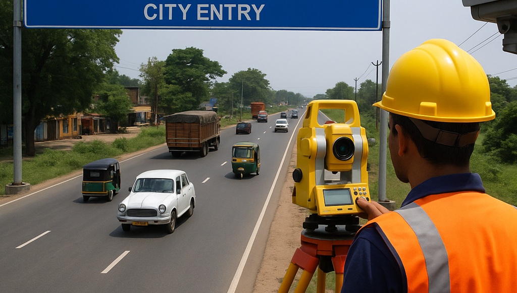
Bhagalpur: A comprehensive Geographical Information System (GIS) Survey has commenced in Bhagalpur city as part of efforts to prepare a futuristic and scientifically planned master plan. As part of the initiative, eight different types of surveys are being conducted, with the External Cordon Survey—a critical component—already underway.

The External Cordon Survey focuses on analyzing vehicular movement and traffic pressure at key entry points to the city. CCTV cameras have been installed at Kajreli, Jagdishpur, Salempur, and Vikramshila Setu to collect data on incoming and outgoing vehicles.
Jaishankar Kumar, representative of Roadies Survey and Data Service Private Limited, the agency conducting the survey, said,

“The External Cordon Survey is essential to understand traffic patterns and transportation stress. This data helps in evaluating the impact of current and future transport projects, and guides planning for road networks, congestion mitigation, and public transit.”
He added that the collected data will help predict how traffic pressure will evolve, which is crucial for effective urban planning.
Surveys to be Completed in 15 Days
All reports are to be compiled and submitted to the Bhagalpur Municipal Corporation within 15 days, following which a new Detailed Project Report (DPR) or master plan will be drafted.
8 Major Surveys Being Conducted
To ensure a holistic understanding of Bhagalpur’s urban dynamics, the following surveys are underway:
- Household Survey – Collects data on residents’ lifestyle, socio-economic status, and basic needs.
- Land Use Survey – Analyzes existing land usage and recommends future land use planning.
- Commercial Structure Survey – Reviews markets, shops, and other commercial spaces.
- Building Structure Survey – Assesses the design, height, and stability of existing buildings.
- Road Network Survey – Studies road width, condition, and future expansion requirements.
- Drainage and Sewerage Survey – Maps drainage structures and evaluates their capacity.
- Public Utility Survey – Checks the condition of water pipelines, electric poles, and street lighting.
- Transport and Connectivity Survey – Evaluates the role of public transport, railway crossings, and pedestrian infrastructure.
Benefits of a GIS-Based Master Plan
- Accurate land use mapping enables optimal zoning for commercial, residential, and agricultural purposes.
- Scientific planning of roads, buildings, and utilities helps address traffic congestion and waterlogging.
- Digitization of property data ensures transparency in land ownership and usage.
- Balanced allocation of civic amenities enhances quality of life and supports sustainable development.
- Disaster management and environmental sustainability will be better integrated into future urban growth strategies.
Officials believe the GIS-based master plan will be a transformative step for Bhagalpur, enabling it to grow as a well-managed and sustainable urban center.


#BiharNews #HigherEducation #BiharStudents #PatnaPress #Education")


