
New Delhi/Patna: The southwest monsoon is expected to arrive over Kerala earlier than usual this year, according to the India Meteorological Department, raising hopes of an early onset of rains across several parts of the country, including Bihar.

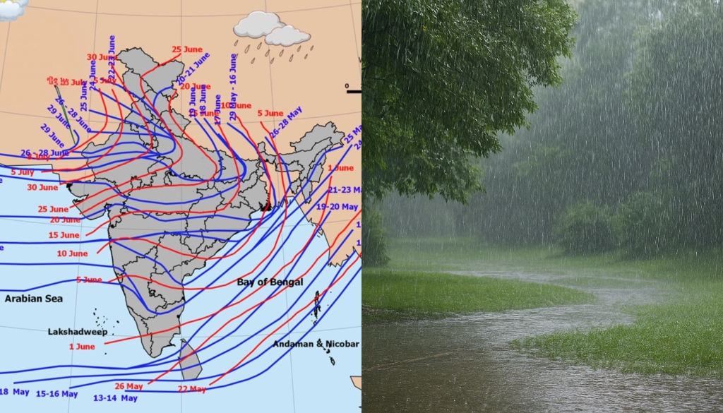
In its latest long-range forecast issued on Friday, the IMD said the southwest monsoon is likely to reach Kerala around May 26, nearly a week ahead of the normal onset date of June 1.
The IMD stated that the forecast carries a model error margin of plus or minus four days.

Bihar Monsoon Likely Between June 8 And June 10
Meteorologists now expect the monsoon to enter Bihar between June 8 and June 10 — approximately four days ahead of the usual June 12–15 onset period.
The southwest monsoon reaches Bihar through the Bay of Bengal branch and typically advances via the districts of:
- Kishanganj
- Purnia
- Katihar
- Araria
- Supaul
- Bhagalpur
before spreading across the rest of the state, including Patna.
Rainfall Likely To Remain Below Normal
Despite the possibility of an early arrival, weather experts have warned that the overall monsoon impact in Bihar may remain weaker than normal.
The benchmark for normal monsoon rainfall in Bihar stands at 992.2 mm. However, meteorologists say rainfall levels have steadily declined over recent years.
According to forecasts:
- rainfall during June and July is likely to remain below normal
- central and western Bihar could witness severe rainfall deficits
- only some northeastern and southeastern pockets may receive relatively better rainfall
Experts warned that weak rainfall during the initial monsoon months could adversely affect:
- agriculture
- irrigation
- groundwater recharge
- water conservation efforts
Districts in South Bihar are expected to remain particularly vulnerable to drought-like conditions if rainfall deficiencies intensify further.

Climate Change And Weakening La Niña Affecting Rainfall Patterns
Meteorological experts attributed the changing rainfall patterns to:
- climate change
- altered cloud formation patterns
- weakening western disturbances
- the diminishing influence of La Niña conditions
Meteorologists said rainfall distribution across Bihar has become increasingly erratic in recent years, with some regions receiving excessive rainfall while others continue facing prolonged deficits.
According to official data, the districts recording the highest rainfall deficits during the previous monsoon season included:
- East Champaran
- Madhepura
- Purnia
- Saharsa
- Araria
- Gopalganj
These districts reportedly recorded rainfall deficits ranging between 49% and 54%.
Extreme Pre-Monsoon Weather Already Seen
Even before the onset of the monsoon, Bihar has witnessed unusually intense pre-monsoon weather activity this year.
The normal rainfall benchmark for May is 37.8 mm, but the state has already recorded an average rainfall of 111 mm during the pre-monsoon period.
Officials said rainfall levels during May were 193% above normal — the highest level recorded for the month.
Heavy storms and lightning strikes have also caused fatalities across Bihar:
- more than a dozen people reportedly died due to lightning on May 4 and 5
- five additional deaths were reported on May 12
Meteorologists attributed the unusually active weather conditions to successive western disturbances and high atmospheric moisture levels affecting large parts of North India, including Punjab and Delhi.
The changing weather pattern has temporarily reduced the intensity of heatwave conditions across Bihar, with several districts experiencing cooler mornings during the second week of May.
Above-Normal Rainfall Recorded Only Three Times In Recent Years
Data from the Meteorological Centre showed Bihar recorded above-normal monsoon rainfall only three times during the past decade:
- 1050 mm in 2019
- 1272 mm in 2020
- 1044.5 mm in 2021
Experts said temperature fluctuations and unstable weather conditions are expected to continue over the coming weeks as the monsoon gradually advances northward.


